Ralston Peak
Twin Bridges, CA
Desolation Wilderness
Elevation 9,239
Found out I was getting half the day off on a Wednesday and felt like I really needed to get gone. Ralston Peak had been on my list and it seemed like the timing was right. I usually try to get out earlier in the day to avoid the heat, but decided to go anyway. It ended up being a hot day and above the tree line I felt like I was a roasted marshmallow for a bit. Was glad to get back into the trees at the end.
Ralston Peak Trail is accessed by driving to Camp Sacramento on Hwy 50. There is a parking lot on the north side of the highway as well as a small access road. If you get there early enough, you can drive up the access road and park right at the trailhead. Being that this was a Wednesday, I was lucky enough to park there.
You will be entering Desolation not far from here, so a permit is needed and available right at the trailhead.
Thankful that part of the trail will be in the shade. Temps are reaching 90+
And off I go!
Gorgeous clear day. Already starting to have some beautiful views
It's a steep climb the entire way, so I'm pacing myself since it's my first time up this one.
Not a bad view, at all...
One of my favorite signs...
This is a pretty heavily trafficked trail, so it's pretty easy to follow.
Although parts are quite rocky.
Views of Sierra at Tahoe ski runs
This part of the trail gets a little sketchy with being able to follow it.
Should have built a cairn or two. Maybe on the next trip.
This part of the trail gets pretty hot. No shade in sight.
And then the peak comes into view.
A short rock scramble and you're there!
The views from the top are amazing!
I didn't spend too much time at the top.
Just long enough to enjoy a nice sandwich and sit down for a bit
and take in the views. I was missing my Get Gone partner
as he had to work. Peak bagging is fun,
but even more fun with the right partner.♥
And back down I go!
I followed it just fine going up, but coming down got a little off trail for a bit.
Although, with this kind of hike it's easy to get back on the right path.
D-O-W-N is the right direction... And I knew it was right on the tree line, so just walked down until I hit trees and walked that contour for a little while. Quickly found the trail again.
Happy Trails!
This hike ended up not being as difficult as I thought it would be. I practically ran back down. I should be able to get up this one faster the next time around.
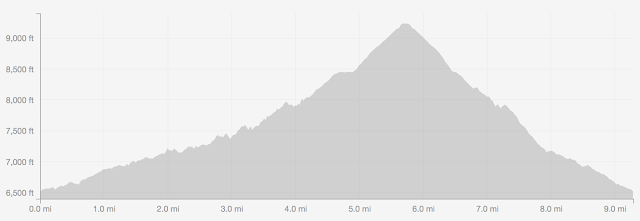
My tracks as recorded by Strava.
3 hours and 45 minutes and just over 3,000 feet of climbing.
Now, go get gone!


Comments
Post a Comment