
Camping and Cave Hiking
Pinnacles National Park
Salinas Valley near Soledad, CA
We decided to close the book on winter this year with a visit to Pinnacles National Park. This was a place Chris had on his to-do list and thankfully, I was able to visit this magical place for the first time with him.
Pinnacles National Park is a U.S. National Park protecting a mountainous area located east of the Salinas Valley in Central California, about 5 miles east of Soledad and 80 miles southeast of San Jose. The park's namesakes are the eroded leftovers of the western half of an extinct volcano that has moved 200 miles from its original location on the San Andreas Fault, embedded in a portion of the California Pacific Coast Ranges. Pinnacles was a National Landmark in 1908 and President Obama made it a National Park in 2013. (Wikipedia)

The week for our trip has finally arrived, so let the food prep begin!! Ok, this is normally done the week before, but neither of us got much done this week, so the DAY before became food prep day. Our gourmet, glamping meals got paired down to really whatever was left in the fridge that was portable and easy to prepare in camp. I did however, have everything I needed to make a grilled vegetable balsamic salad. So, I got busy grilling and was able to assemble this before we left. Everything else was kind of on the fly. Even the horrible tuna sandwich I almost killed Chris with. ;-) Haha
Day 1 - Friday
by Charene

Setting off on our road trip. Let's go, get gone!!

As we are driving, the sky is clearing and we can see all of the beautiful green hills ahead. Our weather is going to be ideal for our getaway and we can already feel the temps rising. Awesome sauce!!

Welcome to Pinnacles National Park.
We have arrived!!

Map of the trails and campground areas.

We checked in at the visitors center and made our way to our campsite.
Home sweet home for the next few days.

I was given a choice: 2 person tent with camping pads and sleeping bags or the 10x10 easy up and a double thick queen sized mattress.
That's an easy one... Glamping please...

We were able to get camp all set up and headed out for some adventure time. We've got about 4 hours of trail time, so we are going to do the smaller inside loop of this side of the park.

Trail map. We are starting on the East Side. Bench Trail to Bear Gulch Trail to Condor Gulch Trail to High Peaks Trail and back down Bench Trail and back to the campground.

We hiked out right from camp, crossed the creek and made our way to the trailhead of the Bench Trail.

Apparently there is a problem with wild pigs.

Please keep the gate closed so they don't come into the campground... Yikes.

This is an easy stroll through grassy fields and wooded creekside trails. It's pushing 80 degrees outside. We are both loving it!!

The poison oak is loving it too. It's all over the place. There are many different kinds on the trail. This is the one I usually find myself getting into trouble with. It's an innocent looking bush all winter, then those mean little red leaves come out when it starts to heat up. This was plentiful all day.

A little more history about how the area was formed.

We went from the Bench Trail to the Bear Gulch Trail.

It's a very well maintained and heavily trafficked trail, but scenic.

We are gaining a little elevation and you can now look down into some canyons.

Walking along the creekside was shaded and beautiful. My view isn't so bad either... ;-)

Postcard perfect scenery.

We crossed a bridge and headed onto the Condor Gulch Trail which will lead us onto the High Peaks Trail.

The trail winds along the canyon.

As we make our way up the grade, the pinnacle rocks are in view. They are very cool. This park is like nothing we've ever seen and experienced in a single location. You'll hike through tropical like shaded creeksides, oak covered canyons and chaparral like desert.
This is also not far from..... where I saw the snake...
This is also not far from..... where I saw the snake...

This is not the "actual" snake, but it was a western diamondback rattlesnake. Chris walked by it and it didn't make a sound. I came up next to it and it snapped like a rubber band and started to rattle. POW. I have never heard one rattle so loud and so instantly. It was coiled up, but quickly retreated into the bushes. I wanted to grab a picture, but I was more worried about trying to catch my breath and stay upright and not pass out. I don't like snakes... at all (Ophidiophobia). I did feel that I handled it pretty well though and was able to compose myself and walk around the area. And I only screamed once... Progress!

More horrible views...

The Pinnacle Rock formations are many different colors. As well as the lichen growing on them. Yellow, Orange, White, Green. It's all very colorful and changes around each bend of the trail.


Some of the rocks appear very sharp and red or dark brown/black. Others are very round and tan.


Oh how we've missed these stunning blue skies through the winter.


We are going to head back down the Bench Trail to our camp. High Peaks and Chaparral will see us tomorrow...


What a gorgeous day. There were areas where the contrast of the bright blue skies, red pinnacle rocks and yellow flowers were all playing off of each other. Hard to capture in one photo, but it was beautiful.

You can take the easy route or the Begg route... You decide...

12.33 miles in just a little over 4 hours. Perfect timing.

And the best part about staying in an actual campground instead of the backcountry? SHOWERS!! OMG. Who knew 3 minutes of hot water could feel so good.

Time for some dinner and a fire! The conductor has also given his cue to the Bullfrog Orchestra to begin their Symphonic performance. They were accompanied by Mr. Turkey who was beckoning for a bride with "gobble, gobble" throughout the evening. And again at 5am the next morning... The fire was amazing! I always love a good campfire. Dinner however, not so much. I made a mediterranean tuna salad to be served in a pita with the grilled vegetable balsamic salad I made in advance. I decided to make mine into a salad with tuna and balsamic veggies on top while Chris' was in a pita with veggies on the side. Feta is mediterranean and goes great with balsamic right? WRONG. It may go well with Kalamata olives and balsamic, but not so much with Tuna. Sorry babe. :-( Should have made yours into a salad too... I'll make up for it with dessert, I promise. Well, I made good on my promise and made an apple crisp over the campfire. He seemed to enjoy that. If I know anything, it's Chris loves his sweet treats... :-) So now I know... Feta and Tuna, that's a no-no.
Day 1 of our adventure is in the books.
Day 2 - Saturday
After a nice breakfast scramble, tea and coffee, we set off on today's big adventure. We've packed snacks and a lunch and plan to be out here all day exploring High Peaks and Caves. Let's go and get gone, again!!
You wouldn't even know from looking at the picture below that I survived having a spider in my ear that Chris discovered as we were hiking out of camp. What is it with bugs and snakes this trip. Seriously? Ok, it was a baby spider and he was able to just wipe it right out, but still creepy nonetheless.
Ok, back to the day's adventure!!
Day 2 - as told by Chris...

After sleeping in and a leisurely start, we are off for a full days adventuring.

Fridays hike took us up to an overlook of the pinnacles but Saturdays trip will take us through two cave systems and up to those pinnacles. Once again we hiked right from our campsite along the the Bench Trail. We will connect up with the Bear Gulch Trail and follow that through the Bear Gulch Cave. We will exit the caves onto the Rim Trail and follow it up to the High Peaks Trail through Juniper Canyon and down to the west side trailhead parking. From there we head onto the Balconies Trail through the Balconies Cave and hike back out on the Old Pinnacles Trail……..whew 20 miles….lets do this.


All of the trails throughout the park are well marked and most are loops that connect with other trails for everything from short walks to big adventures. Today we are connecting loops for a 20 miler. Make sure you pick up a map from the visitors center.

Speluncaphobia.....fear of caves. Each cave system has a bypass trail. Neither of us are big fans of enclosed spaces, so this will be interesting


And here we go.................

The caves in the park are called Talus Caves, they are formed when steep narrow canyons filled with boulders and rocks from the cliffs above. This also allows windows of light to filter in like skylights.


Inside the Bear Gulch Caves are stairs that were constructed in the thirties to help negotiate the trail.
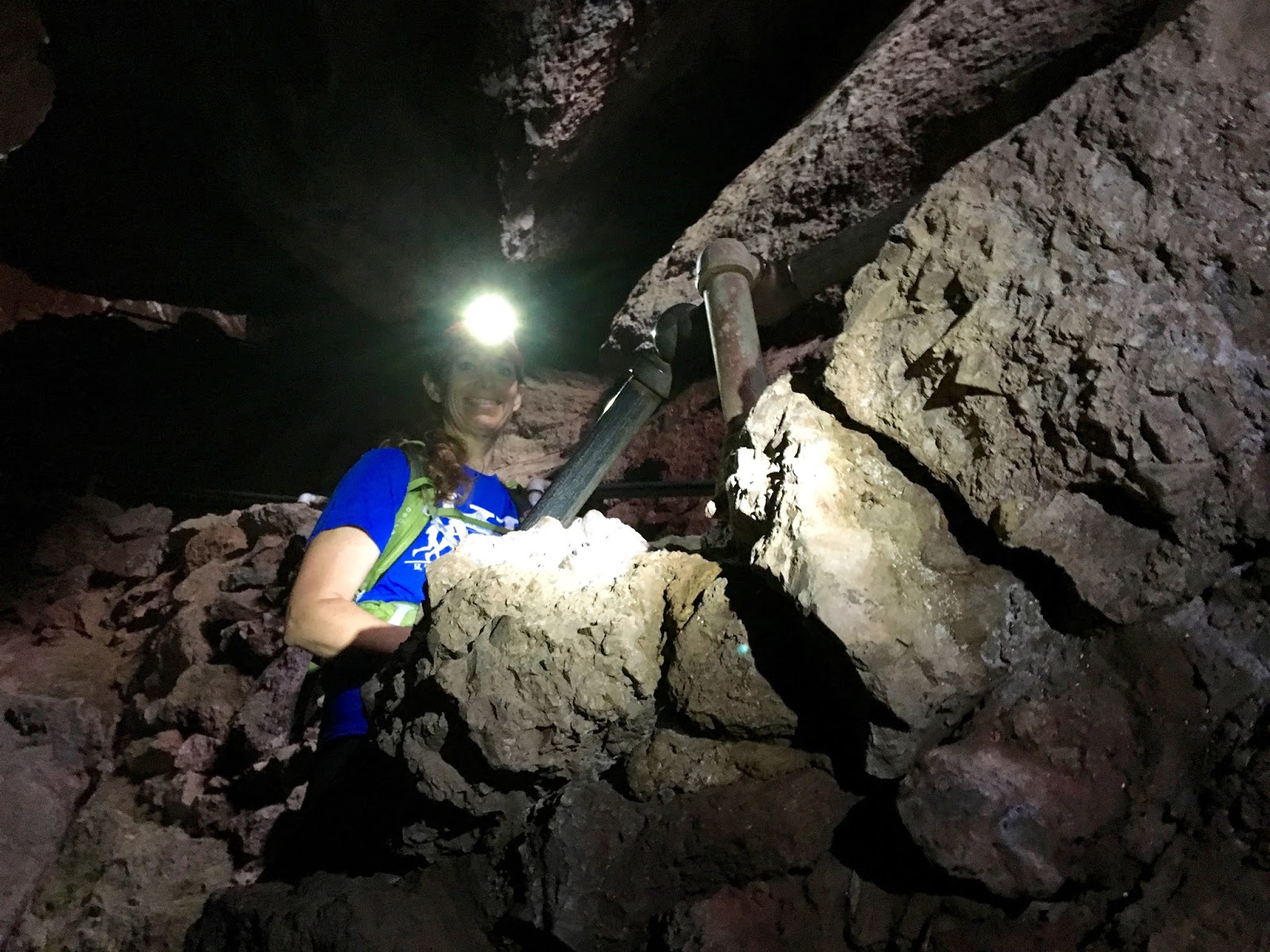
Headlight and flashlights are highly recommended.


Bear Gulch Cave is about a quarter of a mile long. There are segments along the system where sunlight filters down and high ceilings make it easier to manage for those of us who don't like enclosed spaces.

Inside the cave is a creek that runs the length and is fed by springs, creating waterfalls.

Big Smiles........to be out of the main cave section and onto the next section of trail

There are abundant climbing opportunities throughout the park.

This Climbing wall was just outside of the cave across the gulch

The last segment of the cave before we head up to Bear Gulch Reservoir.

Staircase along a waterfall heading up to the Reservoir.

First Cave................Done .........and we both survived, albeit with elevated heart rates and a bit of surging adrenaline.

Bear Gulch Reservoir

Now on to the Rim Trail to meet up with the High Peaks


Along the Rim Trail, looking into Bear Gulch

Saw this little guy sunning himself along the trail. Charene even got close enough to snap a pic..... way to overcome your fear Sweets.

One cave and two snake encounters later..........still smiling.

Now on to the High Peaks Trail toward the Pinnacles


Into the chaparral and up towards the pinnacles


Its called the High Peaks Trail for a reason.

Charene's enjoying the view ;-)

Negotiating the switchbacks and gaining some elevation.

Grilled chicken tabbouleh balela wraps with hummus.

Enjoying lunch, and each others company on the trail at the crest of the High Peaks Trail……the little building is a bathroom.

Now the hike down Juniper Canyon to the Chaparral entrance to the park.

The trail meanders through a series of switchbacks that seem to go on forever. This downhill run went fast, except breaking for all the picture taking


The scenery on the west side is just as breathtaking.

My turn to enjoy the breathtaking beauty on the trail ;-)

Enjoying this….not so much :-(

We made it down to the Chaparral Picnic area and west side park entrance in record time, quick break then back on trail.

The wild flowers where just starting to pop, all throughout the park and made for some great photos.

This next section of trail will follow this creek all through the caves and continue along the Old Pinnacles Trail all the way back to camp.

Last chance to bypass the caves……….

No bypass for us……here we go again…..and still smiling.

It starts out open and then transitions into some pretty tight spaces

Pretty tight…kinda slippery….really steep…butt sliding on rocks steep, no stairs here.

Headlamps on, flashlights on and down we go.


Cave trail selfie under a waterfall inside the Balconies Cave…… I'm pretty sure that I'm forcing a smile, Charene seems to be doing better the me at this point.

And we're out………now that's a real smile.

The Balconies Cave has gates on both sides to close it for when the bats are in residence and also when the water is too hight for passage to be safe.
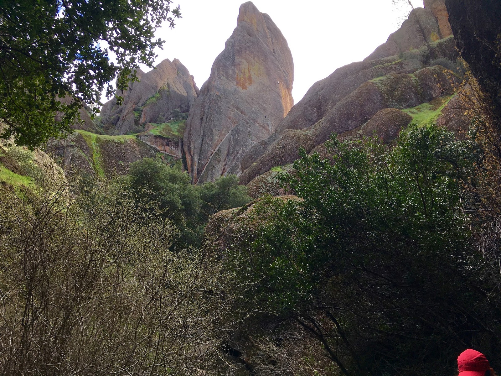
If you look closely you'll see two climber up the face of that pinnacle monolith.


Now for a leisurely stroll the remaining few miles along the creek on the Old Pinnacles Trail


The gray skies we started the day with have now given way to brilliant blues skies…….and long shadows signify the late hour.

Very pretty and easy hike here. We realized that you could probably park at the west entrance and backpack along this trail fairly easily to the campground for a few nights stay while exploring the park and bagging some peaks, then make the hike out. The National Parks unfortunately don't allow back country camping.

Day 3- Sunday
We slept in, again, and had a leisurely morning. Coffee, tea, eggs, bacon and toast by the fire. What a great way to spend the morning. We were going to lounge around camp for a few hours then drive back, but decided since we were already half packed, we might as well head back after breakfast. We broke camp and headed out around noon.
We have both grown up in the area and have seen the signs for Pea Soup Andersen's since childhood but had never eaten there. We decided that on the way home we would stop and have lunch and finally see what the "World's Best Pea Soup" is all about.

We drove for about 45 minutes and arrived at
Pea Soup Andersen's, 12411 CA-33, Gustine, CA 95322
I know what's for lunch... Pea Soup!!!

We both ordered a bowl of pea soup and we decided to split a turkey sandwich. Let's just say we'd probably never eat here again. I'm happy to have checked this one off the list and we will both spend the next couple of days drowning ourselves in water to recover from the sodium bomb. It was flavorful, but very salty. The turkey sandwich (not pictured) was a basic sandwich on wheat bread with deli turkey. Meh. Enough said...
But hey, we can now say we've been there!
Time to finish the trek home so we can begin planning our next adventure.
And the best part of the whole weekend, besides the amazing time we had together exploring this beautiful park, is that tomorrow is the first day of Spring!! Yahoo!!
Comments
Post a Comment