
Andesite Peak
Tahoe National Forest, Nevada County
Elevation 8,219
Snow, Snow and more Snow.
Its been a bit since our last outdoor adventure and the weather hasn't necessarily been assisting in our desire to Get Out and Get Gone. We had a trip in early April through Mojave and to Las Vegas with plans of hiking in the desert and climbing Mt Charleston........but the hundred mile an hour winds and dust storms throughout the area derailed those plans. Taking advantage of a great weather window in late April we decided to get up to the high country and bag a peak.


The Peak is now in full view and feeling a little excited about our first peak of 2017
 And........... that's the top of a tree.
I'm standing on a mountain of snow, on top of a mountain, on top of a tree.


 First Peak of 2017.............and certainly not the last.


 Not a bad view for lunch.


 Plenty of breaks for pics and a nice lunch, so our time was leisurely, but we covered nearly 6 miles. A great day of getting gone in the snow!
Snow, Snow and more Snow.
Its been a bit since our last outdoor adventure and the weather hasn't necessarily been assisting in our desire to Get Out and Get Gone. We had a trip in early April through Mojave and to Las Vegas with plans of hiking in the desert and climbing Mt Charleston........but the hundred mile an hour winds and dust storms throughout the area derailed those plans. Taking advantage of a great weather window in late April we decided to get up to the high country and bag a peak.

Sno-Park parking at Boreal had been plowed.............and there is just a little bit of snow up there.

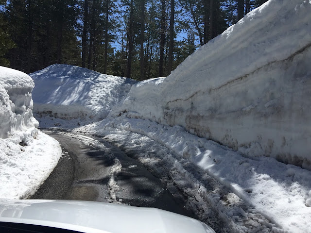
Walls of snow that line the drive into the parking area


The trail up to Andesite and Castle Peaks starts on the north side of 80 at Boreal's exit, however the parking lot there was under 15 to 20 feet of snow, so we parked off Bunny Hill Drive and hiked the underpass but before that we took a selfie...... and saw a GottaGetGone sticker on the street sign..... how did that get there?

Two routes up, one follows the PCT the other is along Castle Valley Road. We stayed on the road to the right, paralleling the PCT route.

At the next junction we stayed left, on road, and keeping the creek to our left. "What Creek" you say, just wait...

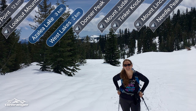
Taking in the views and we decided to play with a new app that Charene learned of at her last SAR training.

I give you.............. ViewRanger. The app has lots of functions but best from my perspective is Skyline. It uses the camera to identify and label landscape features up to 20 miles away. Which is really helpful if you suffer from PIC or Peak Identification Confusion.


Thank you for waiting...............and here's the creek previously mentioned. Upper Castle Creek and about twenty feet of snow covering it to form a precarious snow bridge.

Playing around with Skyline in the ViewRanger app.

Our first glimpse of Andesite peak just past Hole In the Ground Trail connection.

Ascending the ridgeline from Castle Pass and tagging more places to explore this season.

According to intsagram/snapchat/twitter........ this is how you're supposed to do selfies...... with a snow ninja.


Making our way along the ridge and avoiding the cornices off to the side.

The Peak is now in full view and feeling a little excited about our first peak of 2017

I'm standing on a mountain of snow, on top of a mountain, on top of a tree.


Within reach and now its getting steep

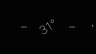
Using a trekking pole and iPhone level as a clinometer

That method would determine that this grade is 31 degrees.


Up up and away.

I've got the peak in my hand


We love to leave things in peak/cache boxes, sign the logs, etc.
This is all the peak there is this time around, so we left a "lucky" penny. (Those pennies that rain down from heaven that you find in parking lots and other various places...)

This is what this peak looks like in the summer!

Coordinates of the peak

Looking back on our tracks.

LUNCH! snacking on hummus and crackers, red bell peppers and turkey/crack sauce (roasted red pepper tomato pesto) sandwiches. Mmmmmm
 Not a bad view for lunch.


Comments
Post a Comment